
Smallest Cities with Light Rail
Public transportation is great, but who wants to take the bus everywhere? In many smaller cities (and a few big ones like Tampa and Columbus), buses are the only public transit infrastructure. Why? They’re cheap and easy. Unlike streetcars, subways, and other forms of light rail, you don’t have to actually move stuff around and build stations and tracks all over the place to let the system function. But trains are faster, don’t add to traffic congestion during rush hour, have lower operating costs per passenger, offer more comfortable rides, and are usually electric vehicles, meaning they are greener than most buses. Here are a few cities with fewer than 300,000 citizens who have put up the cash for a light rail system. Note that this list does not include suburban cities that are connected to the light rail system of a larger neighbor (like Beaverton, Oregon). This list also does not count cities with seasonal tourist trolley systems (like Kenosha, Wisconsin) or systems that are less than 1.5 miles in length (like Savannah, Georgia).
Tacoma, Washington
Population: 192,000
Length of System: 1.6 miles
Number of Stations: 6
Daily Ridership: 3,109
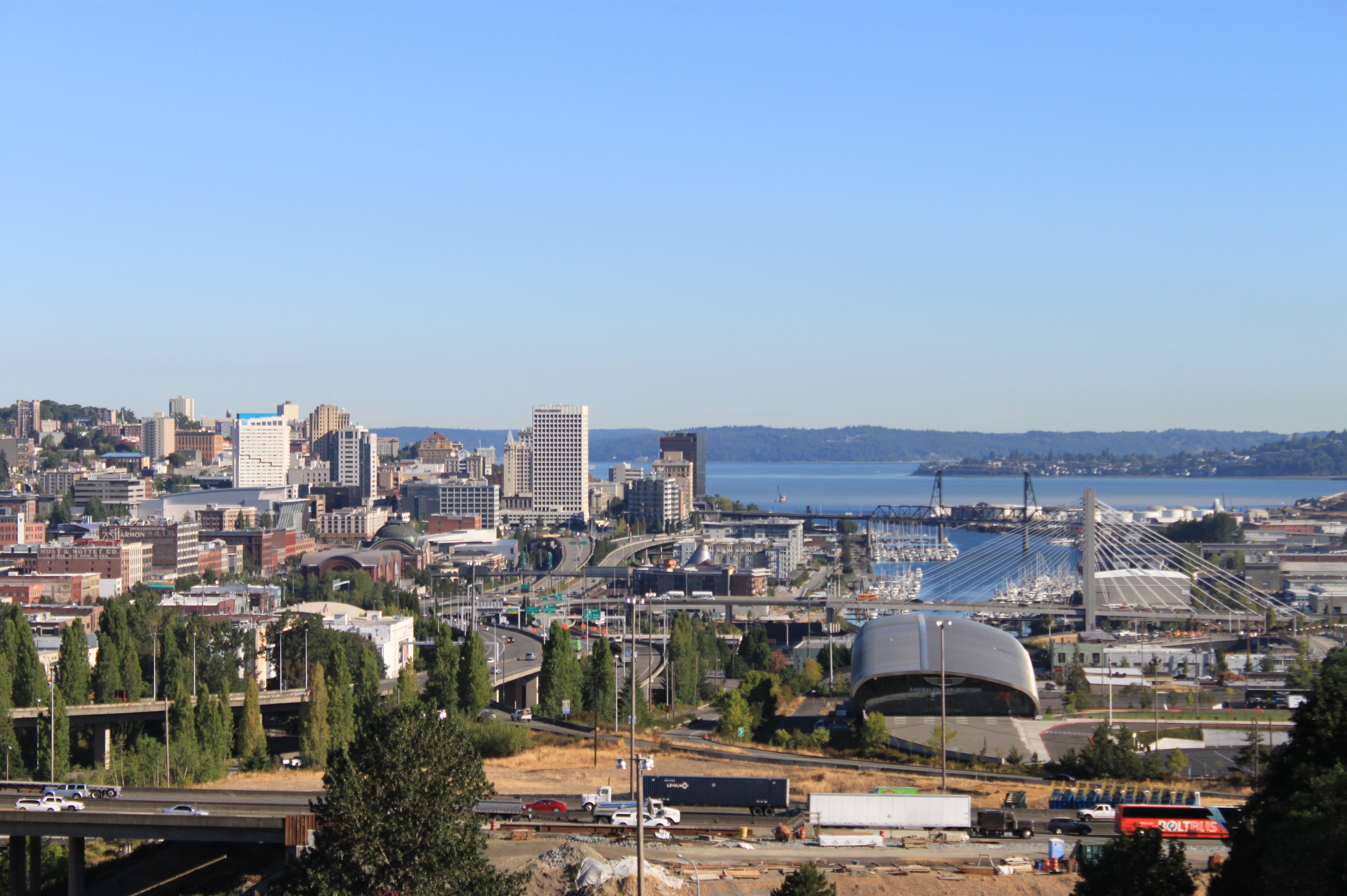
Tacoma, Washington’s Line T is the least used of all the light rail on this list, with just over three thousand people a day using its short length of track. While it won’t get you everywhere you need to go, this street car has a useful route along Commerce Street downtown. It can connect you to many of Tacoma’s central attractions, including the Museum of Glass, the Tacoma Dome, the Brown & Haley chocolate factory store, Pantages Theater, and the Tacoma Convention Center. Due to its short length, the Line T is mostly just a handy way to move around downtown. Great if you live near commerce street or you are visiting and staying in one of the nice downtown hotels, but hardly how most Tacomans get to work.
Norfolk, Virginia
Population: 242,000
Length of System: 7.4 miles
Number of Stations: 11
Daily Ridership: 4,200

The Tide is a strangely named light rail system found in Norfolk, Virginia. It is fairly young, starting operation in 2011, and is the first light rail system in Virginia since the old streetcar system was dismantled there in 1948. The Tide runs east to west through downtown Norfolk, connecting the Eastern Virginia Medical Center just west of downtown with the Ingleside and Easton Forest residential neighborhoods to the east. While it only connects downtown with a handful of Norfolk’s residential areas, people who live east of downtown have a comfortable and reliable method of commuting to the city center. The train runs every 10 minutes during rush hour, and every 15 minutes most other times.
Little Rock, Arkansas
Population: 197,000
Length of System: 3.4 miles
Number of Stations: 15
Daily Ridership: 6,849
While not very long, the Metro Streetcar in Little Rock is one of the most attractive light rail systems in America, thanks to its use of retro streetcars modeled after the Birney-style cars used in the city back in the 1940s. The streetcar line serves both downtown Little Rock and North Little Rock on the other side of the Arkansas River by crossing the Main Street Bridge. As a streetcar, its too slow and short to connect many commuters to their final destinations, but is a handy way of getting around the city center. The Metro Streetcar can drop you off near many of Little Rock’s places of interest, including the Little Rock Convention Center, the Historic Arkansas Museum, and Bill Clinton’s Presidential Library.
Newark, New Jersey
Population: 282,000
Length of System: 6.2 miles
Number of Stations: 17
Daily Ridership: 15,066

Newark may be located just eight miles from New York City, but it has its own public transit system, which includes several miles of light rail. The service is made up of two lines, one serving the downtown area in a short loop, the other connecting the downtown area and Newark’s northern residential areas, including Lower Roseville, Upper Roseville, and Silverlake. This second line is the longer and older portion of the service, and used to be known as the #7 City Subway Line, but is now called the Newark City Subway. As its name implies, part of this line runs underground, though it emerges above ground once it leaves the downtown area. The other line is sometimes called the Broad Street Extension, which runs above ground, other than where it connects to the Newark City Subway near Newark Penn Station. For most riders, the fare is $1.60 one-way, though there are exceptions. The Newark Light Rail is reliable and relatively frequent (about every 20 minutes from 5am to midnight), but the lack of rail service in the eastern and southern portions of the city is noticeable. The most egregious problem is the lack of light rail service to Newark International Airport.
Buffalo, New York
Population: 255,000
Length of System: 6.4 miles
Number of Stations: 14
Daily Ridership: 18,500

Buffalo Metro Rail has served the proud rust belt city of Buffalo New York with a single six and a half mile line since it first opened in 1986. Most of it runs as an underground subway, which is a blessed thing in a city where freezing temperatures and deep snow are commonplace in the winter. Only the downtown stops are above ground, and are located relatively close together. This downtown section runs from KeyBank Center near the Buffalo River to the Fountain Plaza stop on Main Street. From here the line goes underground, and serves the northeastern residential neighborhoods such as Mastern Park, Bryant, Cold Springs, Parkside, and Leroy before ending in University Park. Fare is $2 for a one way ticket, or $75 for a month pass that includes local bus service.
Pittsburgh, Pennsylvania
Population: 300,000
Length of System: 26.2 miles
Number of Stations: 53
Daily Ridership: 26,467

The Pittsburgh Light Rail, more commonly known as ‘the T’, is one of the best public transit systems in a city of its size in the USA. The first line opened in 1984, and the city, county, and state have done more here than in most smaller cities to actually build light rail track and stations. Pittsburgh operates more than 26 miles of track on three lines, though some of this track length is doubled up between the Red, Blue, and Silver lines so it’s not quite as dramatic as it first seems. The T primarily serves downtown and the neighborhoods and suburbs in the southern parts of the city. The lines venture quite far out into these suburbs, and serve the towns of Mt. Lebanon, Castle Shannon, and Bethel Park. Part of the reason for the peculiar arrangement of these lines and how extensive they are for a city the size of Pittsburgh, is that the modern day light rail has repurposed trolley lines from the early 20th century. By the 1980s, most cities had long ago uninstalled and built over their own trolley lines, but Pittsburgh kept them around long enough for public demand for public transportation to return. The old lines were refurbished and the T runs above ground for most of its length, and below ground only in the downtown area.
Salt Lake City, Utah
Population: 200,000
Length of System: 44.8 miles
Number of Stations: 50
Daily Ridership: 67,300

Salt Lake City’s TRAX is perhaps the best light rail system in the country for a small city. With more than 44 miles of track, TRAX actually looks like it was rationally planned out, unlike so many of the half-finished light rail systems on this list. Salt Lake City’s downtown can be reached by light rail from suburbs in every direction, including Ogden to the north, South Jordan to the southwest, and Provo to the southeast. The system also has shorter lines that run east / west through Salt Lake City, connecting its downtown to the University of Utah, the Salt Lake International Airport, Fairmont Park, and West Valley City. But before you go thinking Salt Lake City is a public transit paradise, be aware that the city is geographically huge. The light rail lines are fantastic if you are near one, and the high daily ridership is a testament to their usefulness as commuter lines. But most people in the Salt Lake area are not within walking distance of a light rail station, which are often used in conjunction with park and ride car lots. If you don’t live near one of the fifty light rail stations, you will either need a car or will be forced to rely on the city’s vast but ponderous bus system.